
Mount Semeru
Jawa Timur · 3.676 m a.s.l.
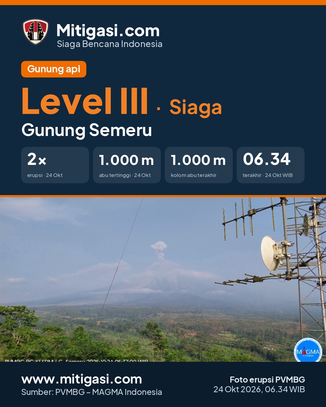
Erupsi terakhir 24 Oct 2026, 07:34 WITA
20 hours ago · waktu setempat 24 Okt 2026, 06:34 WIB
Telah terjadi erupsi G. Semeru,Jawa Timur pada hari Saturday, 24 October 2026, 06:34 WIB dengan tinggi kolom abu teramati ± 1000 m di atas puncak (± 4676.0 m di atas permukaan laut). Kolom abu teramati berwarna putih hingga kelabu dengan intensitas tebal ke arah tenggara. Letusan ini terekam di seismogram dengan amplitudo maksimum 19.0 mm dan durasi sementara +/- 124.0 detik.
PVMBG recommendations
Rekomendasi 1. Tidak melakukan aktivitas apapun di sektor tenggara di sepanjang Besuk Kobokan, sejauh 13 km dari puncak (pusat erupsi). Di luar jarak tersebut, masyarakat tidak melakukan aktivitas pada jarak 500 meter dari tepi sungai (sempadan sungai) di sepanjang Besuk Kobokan karena berpotensi terlanda perluasan awan panas dan aliran lahar hingga jarak 17 km dari puncak. 2. Tidak beraktivitas dalam radius 5 Km dari kawah/puncak Gunung Api Semeru karena rawan terhadap bahaya lontaran batu (pijar). 3. Mewaspadai potensi awan panas, guguran lava, dan lahar di sepanjang aliran sungai/lembah yang berhulu di puncak Gunung Api Semeru, terutama sepanjang Besuk Kobokan, Besuk Bang, Besuk Kembar, dan Besuk Sat serta potensi lahar pada sungai-sungai kecil yang merupakan anak sungai dari Besuk Kobokan.

Eruption at 1705 UTC (0005 local).
Ash-cloud is not observed.
Eruption recorded on seismogram with maximum amplitude 23 mm and maximum duration 115 second.
Recommendations
2. Tidak beraktivitas dalam radius 5 Km dari kawah/puncak Gunung Api Semeru karena rawan terhadap bahaya lontaran batu (pijar).
3. Mewaspadai potensi awan panas, guguran lava, dan lahar di sepanjang aliran sungai/lembah yang berhulu di puncak Gunung Api Semeru, terutama sepanjang Besuk Kobokan, Besuk Bang, Besuk Kembar, dan Besuk Sat serta potensi lahar pada sungai-sungai kecil yang merupakan anak sungai dari Besuk Kobokan.
Latest report
6-hour report, 2026-10-24, 18:00-24:00 WIB · Sigit Rian Alfian
Visual observation
The volcano is covered by fog 0-III. Crater smoke not observed.
Climatology
Weather overcast to rain, weak wind towards west and northwest. Air temperature about 19-20°C.
Seismicity
- 18 Explosion/eruption events, amplitude 10-25 mm, duration 77-183 s.
- 4 Rockfall events, amplitude 1-4 mm, duration 47-57 s.
- 3 Emission events, amplitude 5-7 mm, duration 50-62 s.
- 1 Harmonik event, amplitude 4 mm, duration 119 s.
- 1 Distant tectonic event, amplitude 5 mm, S-P 20 s, duration 41 s.
Observation photo

Latest observation photo.
- Location
- Lumajang, Malang, Jawa Timur
- Nearest city
- Malang, Lumajang, Probolinggo, Pasuruan
- Elevation
- 3.676 m a.s.l.
- Coordinates
- -8.1080000, 112.9200000
Eruptions in the last 30 days (12 terakhir)
- Ash column ± 1.000 m above the summit, duration 124 s
- Ash column ± 700 m above the summit, duration 137 s
- Ash column not observed
- Ash column ± 1.000 m above the summit, duration 85 s
- Ash column ± 1.000 m above the summit, duration 93 s
- Ash column ± 1.200 m above the summit, duration 130 s
- Ash column ± 600 m above the summit, duration 127 s
- Ash column ± 400 m above the summit, duration 122 s
- Ash column ± 800 m above the summit, duration 128 s
- Ash column ± 800 m above the summit, duration 129 s
- Ash column ± 800 m above the summit, duration 132 s
- Ash column ± 700 m above the summit, duration 137 s
VONA – Aviation Notice
Volcano Observatory Notice for Aviation issued by PVMBG for airlines: the colour code shows the volcanic-ash hazard to aircraft. Last 30 days.
-
ORANGE
25 Oct 2026, 01:05 WITA · 2026SMR2012
Abu vulkanik tidak teramati, durasi 115 detik.
VONA text
Eruption at 1705 UTC (0005 local). Ash-cloud is not observed.
-
ORANGE
24 Oct 2026, 22:59 WITA · 2026SMR2011
Abu vulkanik tidak teramati, durasi 160 detik.
VONA text
Eruption at 1459 UTC (2159 local). Ash-cloud is not observed.
-
ORANGE
24 Oct 2026, 20:23 WITA · 2026SMR2010
Abu vulkanik tidak teramati, durasi 125 detik.
VONA text
Eruption at 1223 UTC (1923 local). Ash-cloud is not observed.
-
ORANGE
24 Oct 2026, 07:34 WITA · 2026SMR2009
Volcanic ash ±1.000 m above the summit, duration 124 seconds..
VONA text
Eruption with volcanic ash cloud at 2334 UTC (0634 local). Best estimate of ash-cloud top is around 14963 FT (4676 M) above sea level or 3200 FT (1000 M) above summit. May be higher than what can be observed clearly. Source of height data: ground observer. Ash cloud moving to southeast.
-
ORANGE
24 Oct 2026, 04:18 WITA · 2026SMR2008
Volcanic ash ±700 m above the summit, duration 137 seconds..
VONA text
Eruption with volcanic ash cloud at 2018 UTC (0318 local). Best estimate of ash-cloud top is around 14003 FT (4376 M) above sea level or 2240 FT (700 M) above summit. May be higher than what can be observed clearly. Source of height data: ground observer. Ash cloud moving to southeast.
-
ORANGE
24 Oct 2026, 01:27 WITA · 2026SMR2007
Abu vulkanik tidak teramati, durasi 143 detik.
VONA text
Eruption at 1727 UTC (0027 local). Ash-cloud is not observed.
Observation-post CCTV
Snapshots are updated about every 15 minutes. The capture time is shown in the top-left corner.


Live seismograms
Seismograph (helicorder) records from the last 24 hours at 2 PVMBG stations on Mount Semeru, updated about every 15 minutes. One line = 30 minutes; the bottom line is the latest. Times on the image are UTC (WIB = UTC+7, WITA = UTC+8, WIT = UTC+9). Click an image for full size.
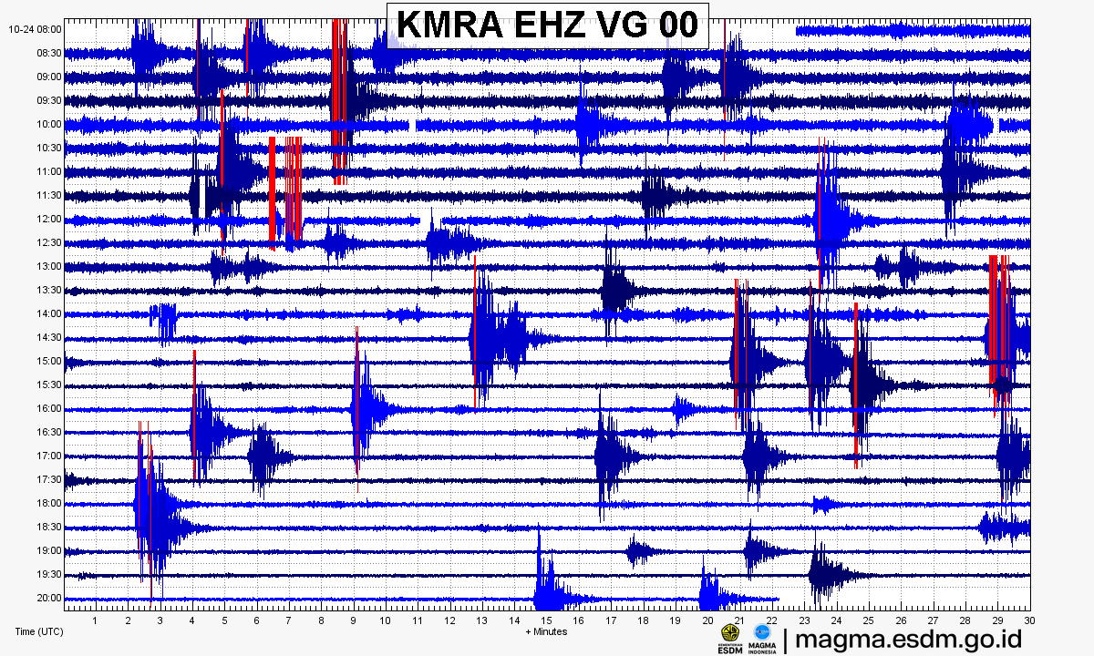
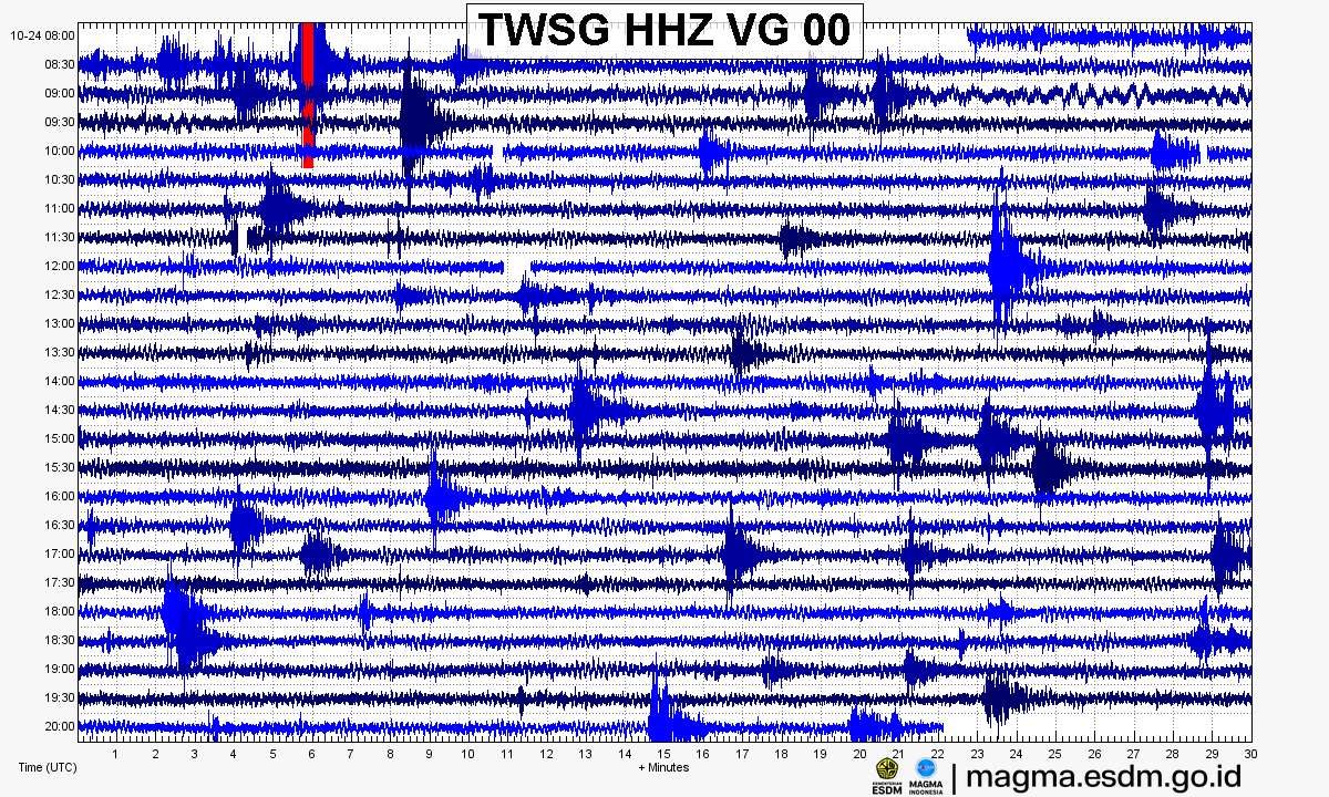
Source: PVMBG – MAGMA Indonesia. Volcanic earthquakes appear as spikes on the trace; continuous shaking may indicate tremor.
14-day seismicity chart
Volcanic earthquakes per day by type.
View data table
| Date | Explosion/eruption | Rockfall | Emission | Deep volcanic | Local tectonic | Distant tectonic |
|---|---|---|---|---|---|---|
| 25 Oct | 0 | 0 | 0 | 0 | 0 | 0 |
| 24 Oct | 132 | 28 | 27 | 1 | 1 | 7 |
| 23 Oct | 166 | 19 | 32 | 2 | 0 | 8 |
| 22 Oct | 130 | 13 | 15 | 0 | 0 | 4 |
| 21 Oct | 39 | 5 | 53 | 0 | 0 | 5 |
| 20 Oct | 66 | 15 | 79 | 0 | 0 | 25 |
| 19 Oct | 130 | 34 | 71 | 0 | 0 | 1 |
| 18 Oct | 0 | 0 | 0 | 0 | 0 | 0 |
| 17 Oct | 0 | 0 | 0 | 0 | 0 | 0 |
| 16 Oct | 0 | 0 | 0 | 0 | 0 | 0 |
| 15 Oct | 0 | 0 | 0 | 0 | 0 | 0 |
| 14 Oct | 0 | 0 | 0 | 0 | 0 | 0 |
| 13 Oct | 0 | 0 | 0 | 0 | 0 | 0 |
| 12 Oct | 0 | 0 | 0 | 0 | 0 | 0 |
Satellite imagery
Previous reports
6-hour report, 2026-10-24, 12:00-18:00 WIB
Visual: The volcano is covered by fog 0-III. Crater smoke not observed.
- 19 Explosion/eruption events, amplitude 10-24 mm, duration 70-117 s.
- 1 Rockfall event, amplitude 2 mm, duration 45 s.
- 2 Emission events, amplitude 4-5 mm, duration 41-51 s.
- 1 Distant tectonic event, amplitude 8 mm, S-P 16 s, duration 39 s.
6-hour report, 2026-10-24, 06:00-12:00 WIB
Visual: The volcano is clearly visible to covered by fog 0-III. No crater smoke.
- 19 Explosion/eruption events, amplitude 13-25 mm, duration 56-173 s.
- 4 Rockfall events, amplitude 3-4 mm, duration 53-198 s.
- 6 Emission events, amplitude 3-8 mm, duration 49-177 s.
24-hour report, 2026-10-24, 00:00-24:00 WIB
Visual: The volcano is clearly visible to covered by fog 0-III. Crater smoke not observed.
- 76 Explosion/eruption events, amplitude 10-25 mm, duration 56-183 s.
- 19 Rockfall events, amplitude 1-8 mm, duration 36-198 s.
- 16 Emission events, amplitude 3-8 mm, duration 41-177 s.
- 2 Harmonik events, amplitude 2-4 mm, duration 119-169 s.
- 1 Deep volcanic event, amplitude 20 mm, S-P 3 s, duration 26 s.
- 1 Local tectonic event, amplitude 2 mm, S-P 10 s, duration 28 s.
- 5 Distant tectonic events, amplitude 1-8 mm, S-P 12-29 s, duration 35-56 s.
6-hour report, 2026-10-24, 00:00-06:00 WIB
Visual: The volcano is clearly visible to covered by fog 0-III. No crater smoke.
- 20 Explosion/eruption events, amplitude 12-25 mm, duration 66-179 s.
- 10 Rockfall events, amplitude 1-8 mm, duration 36-132 s.
- 5 Emission events, amplitude 3-8 mm, duration 41-103 s.
- 1 Harmonik event, amplitude 2 mm, duration 169 s.
- 1 Deep volcanic event, amplitude 20 mm, S-P 3 s, duration 26 s.
- 1 Local tectonic event, amplitude 2 mm, S-P 10 s, duration 28 s.
- 3 Distant tectonic events, amplitude 1-4 mm, S-P 12-29 s, duration 35-56 s.
6-hour report, 2026-10-23, 18:00-24:00 WIB
Visual: The volcano is clearly visible to covered by fog 0-III. Crater smoke not observed.
- 23 Explosion/eruption events, amplitude 12-24 mm, duration 65-179 s.
- 2 Rockfall events, amplitude 2-4 mm, duration 45-49 s.
- 6 Emission events, amplitude 2-7 mm, duration 35-60 s.
- 1 Harmonik event, amplitude 4 mm, duration 224 s.
- 1 Distant tectonic event, amplitude 17 mm, S-P 23 s, duration 67 s.
6-hour report, 2026-10-23, 12:00-18:00 WIB
Visual: The volcano is covered by fog 0-II to covered by fog 0-III. Crater smoke not observed.
- 24 Explosion/eruption events, amplitude 10-24 mm, duration 57-168 s.
- 3 Rockfall events, amplitude 3-6 mm, duration 58-83 s.
- 3 Emission events, amplitude 5-7 mm, duration 40-49 s.
- 1 Harmonik event, amplitude 6 mm, duration 219 s.
- 1 Distant tectonic event, amplitude 8 mm, S-P 14 s, duration 29 s.
6-hour report, 2026-10-23, 06:00-12:00 WIB
Visual: The volcano is clearly visible to covered by fog 0-II. No crater smoke.
- 24 Explosion/eruption events, amplitude 12-25 mm, duration 55-137 s.
- 3 Rockfall events, amplitude 3-6 mm, duration 23-76 s.
- 7 Emission events, amplitude 3-9 mm, duration 20-70 s.
- 1 Deep volcanic event, amplitude 11 mm, S-P 3 s, duration 10 s.
- 2 Distant tectonic events, amplitude 14-30 mm, S-P 18-31 s, duration 61-66 s.
Level history
No level changes recorded since monitoring began.