
Earthquake information
Latest earthquakes in Indonesia
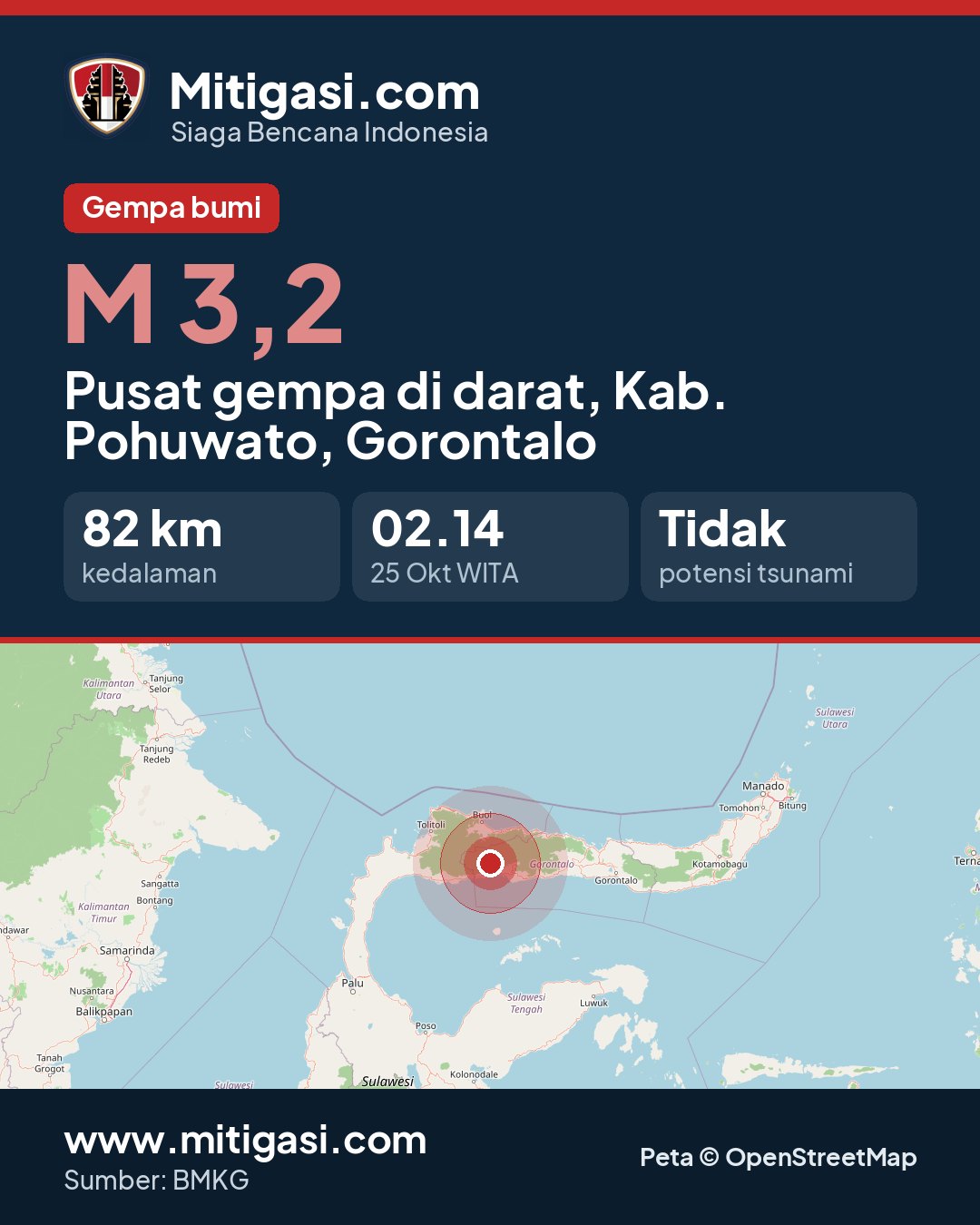
3.2
SR
LATEST EARTHQUAKE
Epicentre on land, Kab. Pohuwato, Gorontalo
No tsunami potential
25 Oct 2026
02:14:49 WITA
82 km
0.658° LU, 121.534° BT
All recorded earthquakes, including small ones. Earthquakes below M 3 are usually not felt.
2.2
Epicentre at sea, 64 km north of Kab. Manggarai Barat, Nusa Tenggara Timur
2.7
Epicentre at sea, 51 km north of Kab. Ende, Nusa Tenggara Timur
2.2
Epicentre at sea, 68 km north of Kab. Ngada, Nusa Tenggara Timur
2.4
Epicentre at sea, 73 km north of Kab. Nagekeo, Nusa Tenggara Timur
2.2
Epicentre at sea, 69 km northeast of Kab. Manggarai Timur, Nusa Tenggara Timur
2.6
Epicentre at sea, 102 km south of Kab. Gunungkidul, DI Yogyakarta
2.6
Epicentre on land, Kab. Banyuwangi, Jawa Timur
3.2
Epicentre on land, Kab. Pohuwato, Gorontalo
2.3
Epicentre at sea, 42 km northwest of Kab. Manggarai Timur, Nusa Tenggara Timur
2.4
Epicentre at sea, 74 km southwest of Kab. Banyuwangi, Jawa Timur
2.1
Epicentre at sea, 59 km north of Kab. Nagekeo, Nusa Tenggara Timur
2.1
Epicentre at sea, 99 km northwest of Kab. Flores Timur, Nusa Tenggara Timur
2.9
Epicentre at sea, 67 km north of Kab. Nagekeo, Nusa Tenggara Timur
2.1
Epicentre at sea, 70 km northwest of Kota Jayapura, Papua
2.8
Epicentre at sea, 67 km southeast of Kota Bima, Nusa Tenggara Barat
2.1
Epicentre on land, Kab. Sumba Barat Daya, Nusa Tenggara Timur
2.9
Epicentre at sea, 66 km north of Kota Sorong, Papua Barat Daya
2.3
Epicentre at sea, 97 km north of Kab. Manggarai, Nusa Tenggara Timur
2.3
Epicentre at sea, 94 km north of Kab. Manggarai, Nusa Tenggara Timur
3.2
Epicentre at sea, 119 km south of Kab. Kepulauan Talaud, Sulawesi Utara
2.1
Epicentre at sea, 43 km north of Kab. Manggarai Timur, Nusa Tenggara Timur
2.2
Epicentre on land, Kab. Boalemo, Gorontalo
2.4
Epicentre at sea, 55 km north of Kab. Manggarai Timur, Nusa Tenggara Timur
2.9
Epicentre at sea, 90 km northeast of Kab. Sumba Timur, Nusa Tenggara Timur
2.6
Epicentre at sea, 23 km north of Kab. Ende, Nusa Tenggara Timur
2.1
Epicentre at sea, 84 km northeast of Kab. Banggai, Sulawesi Tengah
2.8
Epicentre at sea, 68 km north of Kab. Sumba Barat Daya, Nusa Tenggara Timur
2.1
Epicentre at sea, 49 km southwest of Kab. Sumba Barat Daya, Nusa Tenggara Timur
2.1
Epicentre at sea, 43 km northeast of Kab. Dompu, Nusa Tenggara Barat
3.4
Epicentre at sea, 133 km north of Kab. Gresik, Jawa Timur
2.0
Epicentre on land, Kab. Karo, Sumatera Utara
2.9
Epicentre at sea, 79 km north of Kab. Manggarai Timur, Nusa Tenggara Timur
3.1
Epicentre at sea, 76 km north of Kab. Manggarai Timur, Nusa Tenggara Timur
2.4
Epicentre at sea, 79 km north of Kab. Manggarai Timur, Nusa Tenggara Timur
2.2
Epicentre on land, Kab. Bima, Nusa Tenggara Barat
2.5
Epicentre at sea, 71 km north of Kab. Manggarai Timur, Nusa Tenggara Timur
2.3
Epicentre on land, Kab. Manggarai Timur, Nusa Tenggara Timur
5.7
Pusat gempa di Bouvet Island wilayah
3.4
Epicentre at sea, 70 km north of Kab. Ngada, Nusa Tenggara Timur
5.3
Epicentre: Vanuatu Islands
2.5
Epicentre on land, Kab. Kaimana, Papua Barat
2.1
Epicentre at sea, 46 km southwest of Kab. Sumba Barat, Nusa Tenggara Timur
2.0
Epicentre on land, Kab. Raja Ampat, Papua Barat Daya
2.0
Epicentre at sea, 36 km north of Kab. Manggarai Timur, Nusa Tenggara Timur
2.4
Epicentre at sea, 64 km west of Kab. Toli Toli, Sulawesi Tengah
2.9
Epicentre on land, Kab. Biak Numfor, Papua
2.3
Epicentre at sea, 85 km southeast of Kab. Sumbawa, Nusa Tenggara Barat
2.0
Epicentre on land, Kab. Luwu Timur, Sulawesi Selatan
2.4
Epicentre at sea, 57 km east of Kab. Sumba Timur, Nusa Tenggara Timur
2.1
Epicentre at sea, 68 km northeast of Kab. Manggarai Timur, Nusa Tenggara Timur
2.3
Epicentre at sea, 89 km northeast of Kab. Lombok Timur, Nusa Tenggara Barat
2.0
Epicentre at sea, 62 km north of Kab. Manggarai Timur, Nusa Tenggara Timur
3.5
Epicentre at sea, 221 km west of Kab. Kepulauan Tanimbar, Maluku
2.5
Epicentre at sea, 120 km south of Kab. Banyuwangi, Jawa Timur
2.0
Epicentre on land, Kab. Sorong, Papua Barat Daya
2.1
Epicentre at sea, 49 km north of Kab. Manggarai Timur, Nusa Tenggara Timur
4.1
Epicentre at sea, 207 km west of Kab. Kepulauan Tanimbar, Maluku
5.1
Epicentre: Vanuatu Islands
2.3
Epicentre at sea, 70 km south of Kota Gorontalo, Gorontalo
2.6
Epicentre at sea, 61 km east of Kota Bitung, Sulawesi Utara
3.0
Epicentre at sea, 82 km east of Kab. Kep. Siau Tagulandang Biaro, Sulawesi Utara
2.2
Epicentre on land, Kab. Karo, Sumatera Utara
2.2
Epicentre at sea, 73 km north of Kab. Bima, Nusa Tenggara Barat
2.6
Epicentre at sea, 195 km west of Kota Tual, Maluku
2.8
Epicentre on land, Kab. Biak Numfor, Papua
3.2
Epicentre on land, Kab. Manggarai Barat, Nusa Tenggara Timur
2.6
Epicentre at sea, 82 km northwest of Kab. Dompu, Nusa Tenggara Barat
2.6
Epicentre at sea, 67 km north of Kab. Manggarai Barat, Nusa Tenggara Timur
2.5
Epicentre at sea, 90 km south of Kota Denpasar, Bali
3.5
Epicentre at sea, 72 km north of Kab. Manggarai Barat, Nusa Tenggara Timur
2.6
Epicentre at sea, 50 km north of Kab. Manggarai Timur, Nusa Tenggara Timur
2.7
Epicentre at sea, 111 km south of Kab. Banyuwangi, Jawa Timur
2.2
Epicentre at sea, 32 km north of Kab. Manggarai Timur, Nusa Tenggara Timur
4.7
Pusat gempa di Philippine Kepulauan wilayah
2.3
Epicentre at sea, 57 km north of Kab. Manggarai Barat, Nusa Tenggara Timur
3.4
Epicentre at sea, 54 km north of Kab. Manggarai Barat, Nusa Tenggara Timur
2.0
Epicentre at sea, 46 km north of Kab. Manggarai Barat, Nusa Tenggara Timur
5.2
Epicentre: Vanuatu Islands
2.1
Epicentre at sea, 55 km north of Kab. Manggarai Barat, Nusa Tenggara Timur
3.4
Epicentre at sea, 243 km southwest of Kab. Sumba Barat Daya, Nusa Tenggara Timur
2.4
Epicentre at sea, 39 km northwest of Kab. Ende, Nusa Tenggara Timur
3.5
Epicentre at sea, 50 km northwest of Kab. Pulau Morotai, Maluku Utara
2.6
Epicentre at sea, 46 km north of Kab. Nagekeo, Nusa Tenggara Timur
2.2
Epicentre at sea, 61 km north of Kab. Manggarai Timur, Nusa Tenggara Timur
2.0
Epicentre at sea, 38 km north of Kab. Manggarai Timur, Nusa Tenggara Timur
2.5
Epicentre at sea, 16 km north of Kab. Toli Toli, Sulawesi Tengah
2.1
Epicentre at sea, 45 km northwest of Kab. Manggarai Timur, Nusa Tenggara Timur
2.1
Epicentre on land, Kab. Lombok Barat, Nusa Tenggara Barat
5.2
Epicentre: Vanuatu Islands
3.2
Epicentre at sea, 40 km south of Kab. Pesisir Selatan, Sumatera Barat
2.7
Epicentre at sea, 144 km north of Kab. Flores Timur, Nusa Tenggara Timur
3.1
Epicentre at sea, 63 km southwest of Kab. Aceh Barat, Aceh
6.0
Epicentre: Vanuatu Islands
2.7
Epicentre at sea, 47 km northwest of Kab. Manggarai Barat, Nusa Tenggara Timur
2.5
Epicentre on land, Kab. Tanggamus, Lampung
2.8
Epicentre at sea, 84 km south of Kab. Pacitan, Jawa Timur
2.0
Epicentre on land, Kab. Ngada, Nusa Tenggara Timur
5.4
Pusat gempa di Xizang
2.6
Epicentre on land, Kab. Tanggamus, Lampung
5.4
Epicentre: Vanuatu Islands
5.4
Epicentre: Vanuatu Islands
3.6
Epicentre at sea, 245 km south of Kab. Pangandaran, Jawa Barat
2.0
Epicentre on land, Kab. Agam, Sumatera Barat
2.1
Epicentre on land, Kab. Donggala, Sulawesi Tengah
2.0
Epicentre on land, Kab. Manggarai Timur, Nusa Tenggara Timur
2.0
Epicentre at sea, 81 km northeast of Kab. Manggarai Timur, Nusa Tenggara Timur
2.7
Epicentre at sea, 65 km northeast of Kab. Manggarai Timur, Nusa Tenggara Timur
2.7
Epicentre at sea, 96 km northeast of Kab. Banggai, Sulawesi Tengah
5.3
Epicentre: Vanuatu Islands
2.1
Epicentre at sea, 36 km northwest of Kab. Ende, Nusa Tenggara Timur
5.7
Epicentre: Vanuatu Islands
2.0
Epicentre on land, Kab. Poso, Sulawesi Tengah
2.2
Epicentre at sea, 57 km north of Kab. Ngada, Nusa Tenggara Timur
2.0
Epicentre on land, Kab. Manggarai, Nusa Tenggara Timur
2.8
Epicentre at sea, 39 km north of Kab. Manggarai Timur, Nusa Tenggara Timur
2.0
Epicentre on land, Kab. Ende, Nusa Tenggara Timur
5.9
Epicentre: Vanuatu Islands
2.2
Epicentre at sea, 43 km southwest of Kab. Sumba Barat Daya, Nusa Tenggara Timur
2.2
Epicentre on land, Kab. Manggarai Timur, Nusa Tenggara Timur
2.7
Epicentre at sea, 77 km southwest of Kab. Banyuwangi, Jawa Timur
6.1
Epicentre: Vanuatu Islands
2.1
Epicentre on land, Kab. Maluku Tengah, Maluku
2.1
Epicentre at sea, 39 km north of Kab. Ende, Nusa Tenggara Timur
2.3
Epicentre at sea, 65 km north of Kab. Manggarai Barat, Nusa Tenggara Timur
2.3
Epicentre at sea, 47 km northwest of Kab. Manggarai Timur, Nusa Tenggara Timur
2.4
Epicentre at sea, 63 km northeast of Kab. Manggarai Timur, Nusa Tenggara Timur
3.6
Epicentre at sea, 88 km north of Kab. Ende, Nusa Tenggara Timur
2.8
Epicentre at sea, 98 km southeast of Kota Kupang, Nusa Tenggara Timur
2.9
Epicentre at sea, 129 km north of Kab. Gresik, Jawa Timur
6.4
Epicentre: Vanuatu Islands
2.3
Epicentre at sea, 43 km north of Kab. Manggarai, Nusa Tenggara Timur
5.9
Epicentre: Vanuatu Islands
2.4
Epicentre on land, Kab. Karo, Sumatera Utara
3.2
Epicentre at sea, 177 km north of Kab. Kepulauan Talaud, Sulawesi Utara
2.3
Epicentre on land, Kab. Sumba Timur, Nusa Tenggara Timur
5.4
Epicentre: Vanuatu Islands
2.3
Epicentre at sea, 36 km northeast of Kab. Nagekeo, Nusa Tenggara Timur
5.8
Epicentre: Vanuatu Islands
3.4
Epicentre on land, Kab. Aceh Selatan, Aceh
2.5
Epicentre on land, Kab. Manggarai Timur, Nusa Tenggara Timur
6.5
Epicentre: Vanuatu Islands
3.5
Epicentre at sea, 92 km west of Kab. Sumba Barat Daya, Nusa Tenggara Timur
2.4
Epicentre at sea, 34 km north of Kab. Manggarai Timur, Nusa Tenggara Timur
7.3
Epicentre: Vanuatu Islands
3.4
Epicentre at sea, 119 km southeast of Kab Timor Tengah Selatan, Nusa Tenggara Timur
2.9
Epicentre on land, Kab. Banjar, Kalimantan Selatan
2.4
Epicentre at sea, 95 km north of Kab. Sumbawa, Nusa Tenggara Barat
3.1
Epicentre at sea, 84 km north of Kota Bima, Nusa Tenggara Barat
2.5
Epicentre at sea, 45 km north of Kab. Manggarai, Nusa Tenggara Timur
4.0
Epicentre at sea, 81 km southeast of Kab. Kepulauan Sangihe, Sulawesi Utara
3.9
Epicentre at sea, 51 km north of Kab. Manggarai Timur, Nusa Tenggara Timur
2.1
Epicentre at sea, 36 km north of Kab. Ngada, Nusa Tenggara Timur
2.6
Epicentre at sea, 36 km south of Kab. Tulungagung, Jawa Timur
2.8
Epicentre at sea, 67 km northeast of Kab. Banggai Kepulauan, Sulawesi Tengah
3.0
Epicentre at sea, 81 km south of Kab. Bolaang Mongondow Selatan, Sulawesi Utara
3.4
Epicentre at sea, 93 km west of Kab. Toli Toli, Sulawesi Tengah
2.8
Epicentre on land, Kab. Sijunjung, Sumatera Barat
2.1
Epicentre at sea, 41 km north of Kab. Ngada, Nusa Tenggara Timur
2.5
Epicentre at sea, 82 km south of Kab. Malang, Jawa Timur
3.7
Epicentre at sea, 61 km east of Kab. Maluku Barat Daya, Maluku
4.1
Epicentre on land, Kab. Gayo Lues, Aceh
2.7
Epicentre at sea, 93 km south of Kab. Kulon Progo, DI Yogyakarta
2.6
Epicentre at sea, 81 km southwest of Kab. Banggai Kepulauan, Sulawesi Tengah
2.5
Epicentre at sea, 81 km southwest of Kab. Kebumen, Jawa Tengah
2.3
Epicentre on land, Kab. Luwu Utara, Sulawesi Selatan
2.3
Epicentre at sea, 23 km southwest of Kab. Sumba Barat, Nusa Tenggara Timur
2.5
Epicentre on land, Kab. Kepulauan Talaud, Sulawesi Utara
2.8
Epicentre at sea, 145 km east of Kab. Kep. Siau Tagulandang Biaro, Sulawesi Utara
2.5
Epicentre at sea, 47 km northeast of Kab. Lombok Timur, Nusa Tenggara Barat
2.5
Epicentre at sea, 87 km south of Kota Blitar, Jawa Timur
3.0
Epicentre at sea, 153 km south of Kab. Banyuwangi, Jawa Timur
2.7
Epicentre at sea, 94 km southeast of Kab. Sumbawa, Nusa Tenggara Barat
2.7
Epicentre on land, Kab. Manggarai Timur, Nusa Tenggara Timur
2.2
Epicentre at sea, 66 km north of Kab. Manggarai Barat, Nusa Tenggara Timur
2.3
Epicentre on land, Kab. Halmahera Selatan, Maluku Utara
5.5
Epicentre: Vanuatu Islands
2.4
Epicentre at sea, 58 km northeast of Kab. Maluku Tengah, Maluku
2.6
Epicentre at sea, 55 km southwest of Kab. Kaimana, Papua Barat
3.2
Epicentre at sea, 128 km southwest of Kab. Fak Fak, Papua Barat
5.0
Epicentre at sea, 397 km north of Kab. Kepulauan Talaud, Sulawesi Utara
2.2
Epicentre at sea, 36 km northeast of Kab. Nagekeo, Nusa Tenggara Timur
2.6
Epicentre at sea, 36 km northeast of Kab. Nagekeo, Nusa Tenggara Timur
2.9
Epicentre at sea, 128 km southwest of Kab. Fak Fak, Papua Barat
2.7
Epicentre at sea, 146 km southwest of Kab. Fak Fak, Papua Barat
2.5
Epicentre at sea, 54 km north of Kab. Manggarai Barat, Nusa Tenggara Timur
2.2
Epicentre at sea, 85 km north of Kab. Jayapura, Papua
3.5
Epicentre at sea, 44 km north of Kab. Manggarai Barat, Nusa Tenggara Timur
2.5
Epicentre at sea, 88 km southwest of Kab. Sumba Barat Daya, Nusa Tenggara Timur
2.5
Epicentre at sea, 57 km north of Kab. Manggarai Timur, Nusa Tenggara Timur
4.7
Pusat gempa di Taiwan
4.0
Epicentre: South China Sea
2.7
Epicentre at sea, 71 km west of Kab. Sumba Barat Daya, Nusa Tenggara Timur
2.5
Epicentre at sea, 66 km west of Kab. Kaimana, Papua Barat
4.7
Pusat gempa di Eastern Xizang-India Border wilayah
2.0
Epicentre at sea, 42 km northwest of Kab. Ende, Nusa Tenggara Timur
2.5
Epicentre at sea, 52 km northwest of Kab. Manggarai Timur, Nusa Tenggara Timur
2.0
Epicentre at sea, 56 km northwest of Kab. Manggarai Timur, Nusa Tenggara Timur
2.1
Epicentre at sea, 42 km north of Kab. Manggarai Timur, Nusa Tenggara Timur
2.1
Epicentre on land, Kab. Manggarai Timur, Nusa Tenggara Timur
2.2
Epicentre on land, Kab. Sumba Timur, Nusa Tenggara Timur
No earthquakes match this filter.
5.7
Pusat gempa di Bouvet Island wilayah
5.3
Epicentre: Vanuatu Islands
5.1
Epicentre: Vanuatu Islands
5.2
Epicentre: Vanuatu Islands
5.2
Epicentre: Vanuatu Islands
6.0
Epicentre: Vanuatu Islands
5.4
Pusat gempa di Xizang
5.4
Epicentre: Vanuatu Islands
5.4
Epicentre: Vanuatu Islands
5.3
Epicentre: Vanuatu Islands
5.7
Epicentre: Vanuatu Islands
5.9
Epicentre: Vanuatu Islands
6.1
Epicentre: Vanuatu Islands
6.4
Epicentre: Vanuatu Islands
5.9
Epicentre: Vanuatu Islands
5.2
Epicentre on land, 6 km northwest of Lebong
III Kota Bengkulu, II - III Curup, III Arga Makmur
2.5
Epicentre on land, 9 km north of Tanggamus
II Tanggamus
3.9
Epicentre on land, 10 km north of Tanggamus
III Ulu Belu, Tanggamus, III Pulau Panggung, Tanggamus
5.1
62 km northeast of MALUKUBRTDAYA
-
5.4
Epicentre at sea, 59 km southwest of Meulaboh
III Kab. Aceh Selatan, III Kab. Simeulue, III-IV Kab. Aceh Barat, III-IV Kab. Aceh Barat Daya, II Kab. Bener Meriah, II-III Kota Banda Aceh, II-III Kab. Aceh Besar , III-IV Kab. Nagan Raya
3.7
Epicentre at sea, 6 km northwest of Pulau Saringi
III Kab. Sumbawa
3.4
Epicentre on land, 30km Barat Daya Kab. Kupang
III Kab. Kupang, III Kota Kupang
4.2
Epicentre on land, 26 km northeast of Kab. Gayo Lues
III Kab. Gayo Lues, II Aceh Timur
4.5
Epicentre at sea, 60 km north of Labuanbajo
II Kab. Manggarai
4.7
Epicentre at sea, 61 km north of Labuan Bajo
II Kab. Manggarai
4.8
Epicentre at sea, 45 km northeast of Labuan Bajo
I-II Kab. Manggarai
4.1
Epicentre at sea, 56 km north of Ruteng
II-III Kab. Manggarai
5.3
Epicentre at sea, 60 km northeast of Labuan Bajo
IV-V Kab. Manggarai, III Kab. Manggarai Barat, II-III Kab. Bima, II-III Kota Bima, I-II Kab. Nagekeo
2.6
Epicentre on land, 39 km south of Morowali Utara
II - III Kolonodale
4.6
Epicentre at sea, 49 km west of KODI-SUMBABARATDAYA
III Sumba Barat Daya, III Kota Bima, III Kab. Bima, III Sumbawa, III Sumba Barat
M≥3 earthquakes around Indonesia in the last 7 days from international catalogues.
3.5
Minahasa, Sulawesi, Indonesia (BMKG)
3.1
Flores Region, Indonesia (BMKG)
3.2
Kepulauan Talaud, Indonesia (BMKG)
3.0
Flores Sea (BMKG)
3.4
Flores Region, Indonesia (BMKG)
3.2
Flores Region, Indonesia (BMKG)
3.3
Flores Region, Indonesia (BMKG)
3.4
Flores Region, Indonesia (BMKG)
3.0
Mindanao, Philippines (PIVS)
3.5
Halmahera, Indonesia (BMKG)
3.2
Off W Coast Of Northern Sumatra (BMKG)
3.5
Flores Region, Indonesia (BMKG)
3.5
Mindanao, Philippines (BMKG)
3.1
Kepulauan Talaud, Indonesia (PIVS)
3.1
Flores Region, Indonesia (BMKG)
3.0
Sulawesi, Indonesia (BMKG)
3.3
Minahasa, Sulawesi, Indonesia (BMKG)
3.8
Kepulauan Barat Daya, Indonesia (BMKG)
4.6
73 km ENE of Kinablangan, Philippines
4.1
Flores Region, Indonesia (BMKG)
3.3
Near N Coast Of Papua, Indonesia (BMKG)
3.1
Southern Sumatra, Indonesia (BMKG)
3.2
Kepulauan Talaud, Indonesia (PIVS)
3.7
Sumbawa Region, Indonesia (BMKG)
3.6
Celebes Sea (BMKG)
3.1
Mindanao, Philippines (PIVS)
4.1
Papua, Indonesia (BMKG)
3.0
Mindanao, Philippines (PIVS)
3.3
Sumba Region, Indonesia (BMKG)
3.2
Sulawesi, Indonesia (BMKG)
3.2
Kepulauan Talaud, Indonesia (PIVS)
3.6
Kepulauan Babar, Indonesia (BMKG)
3.8
Papua, Indonesia (BMKG)
4.2
197 km W of Tual, Indonesia
4.0
Sumba Region, Indonesia (BMKG)
4.5
207 km NE of Lospalos, Timor Leste
4.0
Molucca Sea (BMKG)
3.7
Banda Sea (BMKG)
3.7
Mindanao, Philippines (PIVS)
4.5
18 km WNW of Bantogon, Philippines
3.4
Molucca Sea (BMKG)
3.8
Seram, Indonesia (BMKG)
3.1
Northern Sumatra, Indonesia (BMKG)
3.4
Mindanao, Philippines (PIVS)
3.0
Mindanao, Philippines (PIVS)
3.0
Mindanao, Philippines (PIVS)
3.0
Kepulauan Talaud, Indonesia (PIVS)
3.2
Molucca Sea (BMKG)
4.3
Molucca Sea (BMKG)
4.9
Molucca Sea (EMSC)
4.1
Banda Sea (BMKG)
3.0
Kep. Mentawai Region, Indonesia (BMKG)
4.2
Molucca Sea (BMKG)
3.5
Halmahera, Indonesia (BMKG)
3.1
Papua, Indonesia (BMKG)
3.7
Java, Indonesia (BMKG)
3.4
Mindanao, Philippines (BMKG)
3.0
Mindanao, Philippines (PIVS)
4.9
85 km NNW of Curup, Indonesia
3.4
Near N Coast Of Papua, Indonesia (BMKG)
3.1
Molucca Sea (BMKG)
3.3
Papua, Indonesia (BMKG)
3.2
Flores Region, Indonesia (BMKG)
3.4
Mindanao, Philippines (PIVS)
3.8
Moro Gulf, Mindanao, Philippines (PIVS)
3.4
Flores Region, Indonesia (BMKG)
3.8
Sulawesi, Indonesia (BMKG)
3.4
Northern Sumatra, Indonesia (BMKG)
4.4
Banda Sea
3.9
South Of Java, Indonesia (BMKG)
3.1
Mindanao, Philippines (PIVS)
3.2
Sumbawa Region, Indonesia (BMKG)
3.6
Off W Coast Of Northern Sumatra (BMKG)
3.7
Southern Sumatra, Indonesia (BMKG)
5.1
164 km NE of Lospalos, Timor Leste
4.0
Seram, Indonesia (BMKG)
3.7
Banda Sea (BMKG)
3.8
Flores Region, Indonesia (BMKG)
3.4
Molucca Sea (BMKG)
3.0
Flores Region, Indonesia (BMKG)
3.1
Philippine Islands Region (PIVS)
3.9
Flores Sea (BMKG)
3.2
Kepulauan Talaud, Indonesia (PIVS)
4.2
152 km WNW of Tobelo, Indonesia
3.5
Molucca Sea (PIVS)
5.0
21 km SW of Meulaboh, Indonesia
3.2
Flores Region, Indonesia (BMKG)
3.0
Mindanao, Philippines (PIVS)
4.0
South Of Sumbawa, Indonesia (BMKG)
4.5
142 km SSW of Abepura, Indonesia
3.2
Flores Region, Indonesia (BMKG)
4.4
26 km WSW of Balangonan, Philippines
3.8
Lombok Region, Indonesia (BMKG)
3.5
Nias Region, Indonesia (BMKG)
3.6
Timor Region, Indonesia (BMKG)
3.2
Java, Indonesia (BMKG)
3.2
Timor Region (BMKG)
3.1
Flores Region, Indonesia (BMKG)
3.0
Flores Sea (BMKG)
3.3
Molucca Sea (BMKG)
4.3
248 km SW of Tambolaka, Indonesia
3.2
Flores Region, Indonesia (BMKG)
3.9
Halmahera, Indonesia (BMKG)
3.1
Java, Indonesia (BMKG)
3.1
Lombok Region, Indonesia (BMKG)
4.4
147 km ENE of Lospalos, Timor Leste
3.6
Near N Coast Of Papua, Indonesia (BMKG)
3.2
Kep. Mentawai Region, Indonesia (BMKG)
3.0
Halmahera, Indonesia (BMKG)
3.8
Banda Sea (BMKG)
3.2
Bali Region, Indonesia (BMKG)
3.7
Papua, Indonesia (BMKG)
3.3
Flores Region, Indonesia (BMKG)
4.3
Northern Sumatra, Indonesia (BMKG)
3.2
Flores Region, Indonesia (BMKG)
3.1
Sulawesi, Indonesia (BMKG)
4.8
56 km N of Ruteng, Indonesia
4.1
192 km NE of Lospalos, Timor Leste
3.5
Flores Region, Indonesia (BMKG)
4.7
53 km NNE of Labuan Bajo, Indonesia
3.0
Flores Region, Indonesia (BMKG)
4.9
54 km NE of Labuan Bajo, Indonesia
4.7
163 km WNW of Tobelo, Indonesia
4.4
Banda Sea (BMKG)
3.1
Philippine Islands Region (PIVS)
3.1
Flores Region, Indonesia (BMKG)
4.5
Banda Sea
3.3
Flores Region, Indonesia (BMKG)
3.3
Java, Indonesia (BMKG)
3.7
Mindanao, Philippines (PIVS)
4.2
North Of Halmahera, Indonesia (BMKG)
3.9
North Of Halmahera, Indonesia (BMKG)
3.3
Sumbawa Region, Indonesia (BMKG)
4.1
Celebes Sea (BMKG)
4.4
223 km NE of Lospalos, Timor Leste
3.6
Kepulauan Alor, Indonesia (BMKG)
3.1
Molucca Sea (BMKG)
3.6
Kepulauan Sula, Indonesia (BMKG)
3.1
Flores Region, Indonesia (BMKG)
3.7
South Of Sumbawa, Indonesia (BMKG)
3.0
Flores Region, Indonesia (BMKG)
3.2
Java, Indonesia (BMKG)
3.4
Minahasa, Sulawesi, Indonesia (BMKG)
3.0
Sulawesi, Indonesia (BMKG)
3.0
Flores Sea (BMKG)
3.9
Off W Coast Of Northern Sumatra (BMKG)
4.2
Flores Region, Indonesia (BMKG)
5.2
55 km NNW of Ruteng, Indonesia
3.1
Flores Region, Indonesia (BMKG)
3.4
Sulawesi, Indonesia (BMKG)
3.8
Sulawesi, Indonesia (BMKG)
3.2
Molucca Sea (BMKG)
4.2
Kepulauan Babar, Indonesia (BMKG)
3.2
South Of Java, Indonesia (BMKG)
Red: earthquakes in Indonesia. Blue: international catalogue (7 days). Circle size follows magnitude; orange lines are active faults.
30-Day Earthquake Statistics
2,371earthquakes recorded
143M≥2.5 earthquakes (international)
7.3
strongest: Epicentre: Vanuatu Islands
Earthquakes per day (M≥2.5)
Magnitude distribution
Earthquake & Tsunami Preparedness
During an earthquake
- Drop, Cover, Hold On: take cover under a sturdy table and protect your head and neck.
- Stay away from glass, cabinets, and anything that can fall. Do not run outside during strong shaking.
- If outdoors, move away from buildings, power poles, and trees.
After an earthquake
- Leave calmly by the stairs, not the lift. Watch for aftershocks.
- Check for gas leaks and electrical shorts; switch off the power if needed.
- Follow official BMKG/BPBD information and do not spread unverified news.
Tsunami signs
- On the coast, a strong or long earthquake (hard to stand) is a natural warning: move to high ground immediately, do not wait for a siren.
- Sudden sea retreat or a roar from the sea: evacuate at once.
- Stay somewhere safe until officials announce the threat is over.