
Mount Marapi
Sumatera Barat · 2.891 m a.s.l.
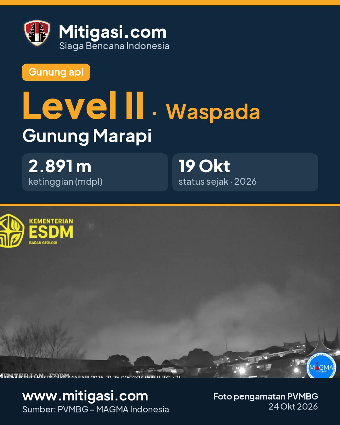
Recommendations
2. Masyarakat yang bermukim di sekitar lembah/aliran/bantaran sungai-sungai yang berhulu di puncak G. Marapi agar selalu mewaspadai potensi ancaman bahaya lahar yang dapat terjadi terutama di saat musim hujan.
3. Jika terjadi hujan abu maka masyarakat diimbau untuk menggunakan masker penutup hidung dan mulut untuk menghindari gangguan saluran pernapasan (ISPA), serta perlengkapan lain untuk melindungi mata dan kulit. Selain itu agar mengamankan sarana air bersih serta membersihkan atap rumah dari abu vulkanik yang tebal agar tidak roboh
4. Seluruh pihak agar menjaga suasana yang kondusif di masyarakat, tidak menyebarkan narasi bohong (hoax), dan tidak terpancing isu-isu yang tidak jelas sumbernya. Masyarakat harap selalu mengikuti arahan dari Pemerintah Daerah.
5. Pemerintah Daerah Kota Bukittinggi, Kota Padang Panjang, Kabupaten Tanah Datar, dan Kabupaten Agam agar senantiasa berkoordinasi dengan Pusat Vulkanologi dan Mitigasi Bencana Geologi di Bandung atau dengan Pos Pengamatan G. Marapi di Jl. Prof. Hazairin No.168 Bukittinggi untuk mendapatkan informasi langsung tentang aktivitas G. Marapi.
6. Masyarakat dapat memantau perkembangan aktivitas dan rekomendasi G. Marapi melalui aplikasi android MAGMA Indonesia yang dapat diunduh dari Google Playstore atau melalui website https://magma.esdm.go.id, https://vsi.esdm.go.id, dan https://geologi.esdm.go.id.
Latest report
24-hour report, 2026-10-24, 00:00-24:00 WIB · Ilhamdi Saputra
Visual observation
The volcano is covered by fog 0-I to covered by fog 0-III. Crater smoke not observed. Weather cloudy to rain, weak wind towards northeast, east and southeast. Air temperature about 17.0-19.0°C. Humidity 100.0%. Air pressure 637.5-639.8 mmHg.
Ada peningkatan aktivitas kegempaan Gunungapi Marapi, agar tetap waspada dan mematuhi zona rekomendasi dari Badan Geologi
Climatology
Weather cloudy to rain, weak wind towards northeast, east and southeast. Air temperature about 17.0-19.0°C. Humidity 100.0%. Air pressure 637.5-639.8 mmHg.
Seismicity
- 1 Local tectonic event, amplitude 3.0 mm, S-P 8.6 s, duration 29.0 s.
- 4 Distant tectonic events, amplitude 1.0-17.3 mm, S-P 14.0-35.0 s, duration 41.0-82.0 s.
- 5 Deep volcanic events, amplitude 0.7-23.0 mm, S-P 1.7-3.5 s, duration 9.0-16.0 s.
- 2 Shallow volcanic events, amplitude 0.6-1.6 mm, duration 8.0-23.0 s.
Observation photo

Latest observation photo.
- Location
- Agam, Tanah Datar, Sumatera Barat
- Nearest city
- Bukittinggi, Padang Panjang
- Elevation
- 2.891 m a.s.l.
- Coordinates
- -0.3810000, 100.4730000
Observation-post CCTV
Snapshots are updated about every 15 minutes. The capture time is shown in the top-left corner.


Live seismograms
Seismograph (helicorder) records from the last 24 hours at 1 PVMBG stations on Mount Marapi, updated about every 15 minutes. One line = 30 minutes; the bottom line is the latest. Times on the image are UTC (WIB = UTC+7, WITA = UTC+8, WIT = UTC+9). Click an image for full size.
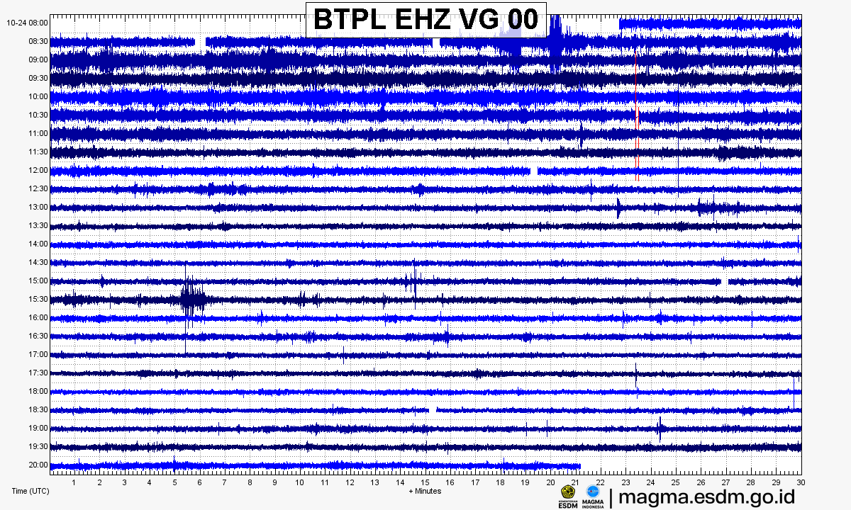
Source: PVMBG – MAGMA Indonesia. Volcanic earthquakes appear as spikes on the trace; continuous shaking may indicate tremor.
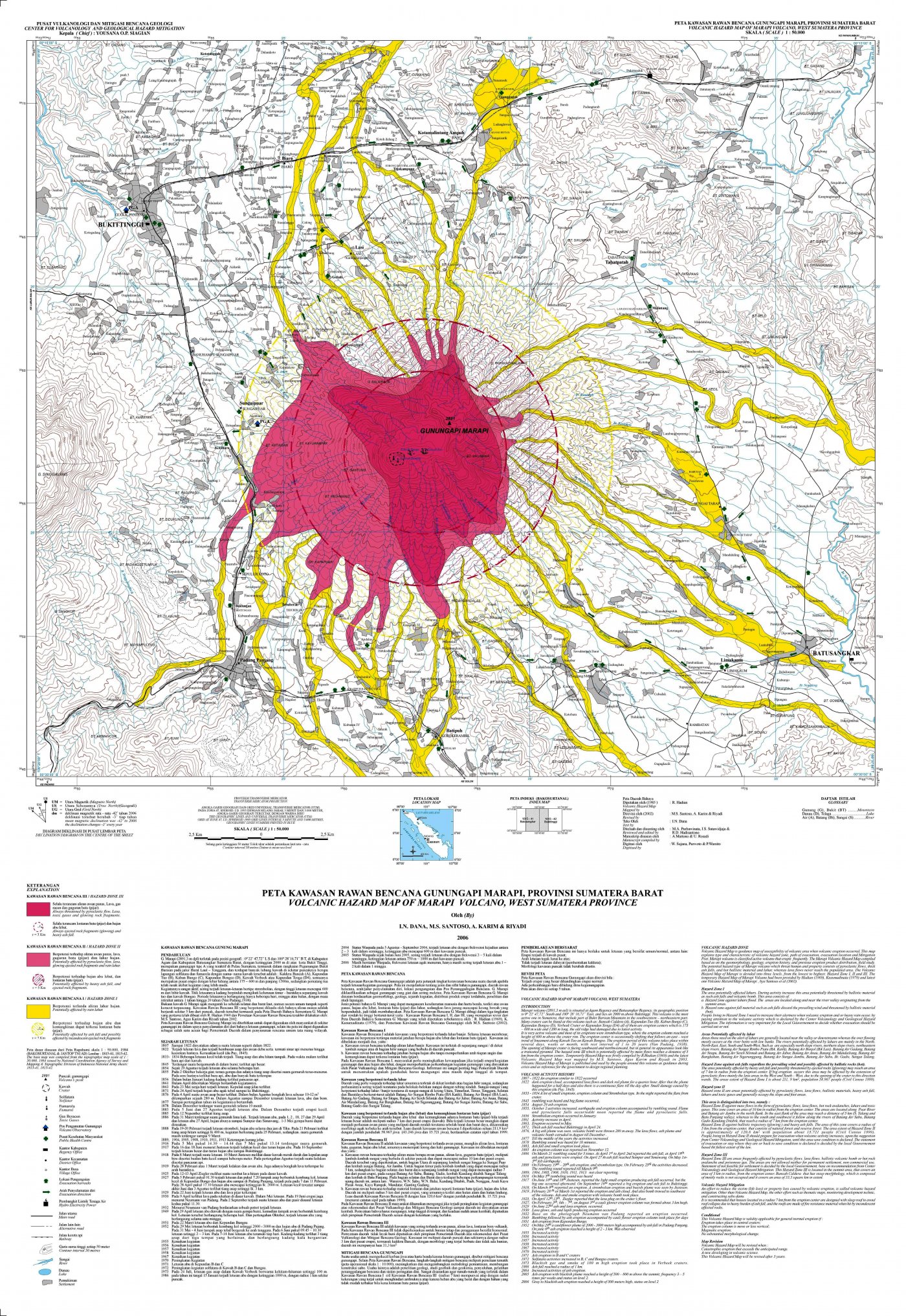
Volcanic hazard map (KRB)
Official Geological Agency map (2006): areas that may be hit by pyroclastic flows, lava flows, ballistic rocks, ashfall, and lahars. KRB III is closest to the source.
14-day seismicity chart
Volcanic earthquakes per day by type.
View data table
| Date | Emission | Shallow volcanic | Deep volcanic | Local tectonic | Distant tectonic |
|---|---|---|---|---|---|
| 25 Oct | 0 | 0 | 0 | 0 | 0 |
| 24 Oct | 0 | 2 | 5 | 1 | 4 |
| 23 Oct | 0 | 2 | 0 | 1 | 3 |
| 22 Oct | 0 | 0 | 4 | 5 | 4 |
| 21 Oct | 0 | 0 | 3 | 3 | 6 |
| 20 Oct | 8 | 2 | 2 | 2 | 4 |
| 19 Oct | 7 | 1 | 3 | 3 | 3 |
| 18 Oct | 5 | 0 | 1 | 1 | 1 |
| 17 Oct | 0 | 0 | 0 | 0 | 0 |
| 16 Oct | 0 | 0 | 0 | 0 | 0 |
| 15 Oct | 0 | 0 | 0 | 0 | 0 |
| 14 Oct | 0 | 0 | 0 | 0 | 0 |
| 13 Oct | 0 | 0 | 0 | 0 | 0 |
| 12 Oct | 0 | 0 | 0 | 0 | 0 |
Satellite imagery
Previous reports
24-hour report, 2026-10-23, 00:00-24:00 WIB
Visual: The volcano is covered by fog 0-III. Crater smoke not observed.
- 2 Shallow volcanic events, amplitude 0.8-1.2 mm, duration 10-23 s.
- 1 Local tectonic event, amplitude 4.9 mm, S-P 6.4 s, duration 24 s.
- 3 Distant tectonic events, amplitude 1.2-6.9 mm, S-P 15.6-35 s, duration 27-70 s.
24-hour report, 2026-10-22, 00:00-24:00 WIB
Visual: The volcano is covered by fog 0-III. Crater smoke not observed.
- 4 Deep volcanic events, amplitude 1.2-2.3 mm, S-P 0.8-2.1 s, duration 10-29 s.
- 5 Local tectonic events, amplitude 1-5.4 mm, S-P 3.5-7 s, duration 22-32 s.
- 4 Distant tectonic events, amplitude 1.7-28.7 mm, S-P 27.3-44.5 s, duration 97-491 s.
24-hour report, 2026-10-21, 00:00-24:00 WIB
Visual: The volcano is covered by fog 0-III. Crater smoke not observed.
- 3 Deep volcanic events, amplitude 1.5-6.8 mm, S-P 2.1-2.8 s, duration 10-31 s.
- 3 Local tectonic events, amplitude 1.6-5.3 mm, S-P 3.9-9.3 s, duration 23-39 s.
- 6 Distant tectonic events, amplitude 1-3.9 mm, S-P 12-31 s, duration 38-82 s.
24-hour report, 2026-10-20, 00:00-24:00 WIB
Visual: The volcano is covered by fog 0-III. Crater smoke not observed.
- 8 Emission events, amplitude 1.4-1.8 mm, duration 28-52 s.
- 1 Tremor Non-Harmonik event, amplitude 1.6 mm, duration 82 s.
- 2 Shallow volcanic events, amplitude 1.4-1.6 mm, duration 12-13 s.
- 2 Deep volcanic events, amplitude 1.8-4.2 mm, S-P 2.6-2.8 s, duration 8-16 s.
- 2 Local tectonic events, amplitude 1.8-7.9 mm, S-P 4.5-6.8 s, duration 20-21 s.
- 4 Distant tectonic events, amplitude 1.4-7.3 mm, S-P 19-39 s, duration 41-187 s.
24-hour report, 2026-10-19, 00:00-24:00 WIB
Visual: The volcano is covered by fog 0-III. Crater smoke not observed.
- 7 Emission events, amplitude 1.4-1.5 mm, duration 24-53 s.
- 2 Tremor Non-Harmonik events, amplitude 1.4 mm, duration 96-103 s.
- 1 Shallow volcanic event, amplitude 1.5 mm, duration 9 s.
- 3 Deep volcanic events, amplitude 1.9-4.8 mm, S-P 0.9-2.6 s, duration 7-8 s.
- 3 Local tectonic events, amplitude 1.4-5.4 mm, S-P 3-5 s, duration 14-20 s.
- 3 Distant tectonic events, amplitude 1.5-4.6 mm, S-P 31-96 s, duration 62-174 s.
24-hour report, 2026-10-18, 00:00-24:00 WIB
Visual: The volcano is covered by fog 0-III. Crater smoke not observed.
- 5 Emission events, amplitude 1.2-1.4 mm, duration 39-67 s.
- 2 Tremor Non-Harmonik events, amplitude 1.2-3.1 mm, duration 86-115 s.
- 1 Deep volcanic event, amplitude 1.5 mm, S-P 2.4 s, duration 12 s.
- 1 Local tectonic event, amplitude 27.9 mm, S-P 3.1 s, duration 27 s.
- 1 Distant tectonic event, amplitude 1.6 mm, S-P 20 s, duration 72 s.
Level history
No level changes recorded since monitoring began.