
Mount Anak Krakatau
Lampung · 157 m a.s.l.
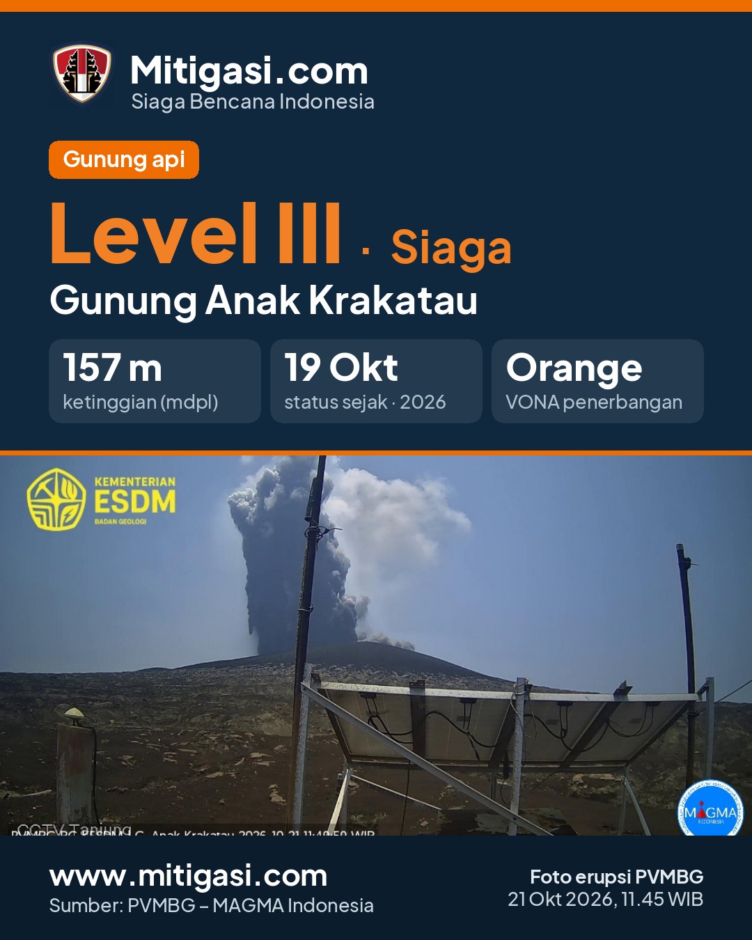
Erupsi terakhir 21 Oct 2026, 12:45 WITA
3 days ago · waktu setempat 21 Okt 2026, 11:45 WIB
Telah terjadi erupsi G. Anak Krakatau,Lampung pada hari Wednesday, 21 October 2026, 11:45 WIB dengan tinggi kolom abu teramati ± 500 m di atas puncak (± 657.0 m di atas permukaan laut). Kolom abu teramati berwarna hitam dengan intensitas tebal ke arah barat laut. Letusan ini terekam di seismogram dengan amplitudo maksimum 70.0 mm dan durasi sementara +/- 0.0 detik. Letusan masih berlangsung saat laporan ini dibuat.
PVMBG recommendations
1. Masyarakat di sekitar Gunungapi Anak Krakatau dan pengunjung/wisatawan/pendaki tidak diperbolehkan memasuki dan melakukan kegiatan di dalam wilayah radius 5 km dari pusat erupsi Anak Krakatau. 2. Masyarakat di sekitar Gunungapi Anak Krakatau dan pengunjung/wisatawan tidak diperbolehkan memasuki dan melakukan kegiatan di dalam wilayah radius 1 km dari pulau baru di sektor barat laut dan tenggara Gunungapi Anak Krakatau. 3. Meningkatkan kewaspadaan terhadap ancaman bahaya lontaran batu pijar, hujan abu lebat, aliran lava, dan potensi erupsi sekunder yang ditimbulkan oleh kontak panas lava, baik dengan air laut maupun air hujan dalam radius 5 km dari pusat erupsi Anak Krakatau. 4. Masyarakat di wilayah pantai Provinsi Banten dan Lampung harap tenang dan jangan mempercayai isu-isu tentang erupsi Gunungapi Anak Krakatau yang akan menyebabkan tsunami, serta dapat melakukan kegiatan seperti biasa dengan senantiasa mengikuti arahan BPBD setempat. 5. Untuk mengetahui informasi dapat menghubungi Pusat Vulkanologi dan Mitigasi Bencana Geologi, Badan Geologi (022) 7272606 di Bandung (Provinsi Jawa Barat) atau Pos Pengamatan Gunungapi Krakatau (0254) 651449 atau 085846324506 di Pasauran (Provinsi Banten).

Eruption with volcanic ash cloud at 0445 UTC (1145 local).
Best estimate of ash-cloud top is around 2102 FT (657 M) above sea level or 1600 FT (500 M) above summit. May be higher than what can be observed clearly. Source of height data: ground observer.
Eruption and ash emission is continuing. Eruption recorded on seismogram with maximum amplitude 70 mm. Tremor recorded on seismogram with maximum amplitude 70 mm.
Recommendations
2. Masyarakat di sekitar Gunungapi Anak Krakatau dan pengunjung/wisatawan tidak diperbolehkan memasuki dan melakukan kegiatan di dalam wilayah radius 1 km dari pulau baru di sektor barat laut dan tenggara Gunungapi Anak Krakatau.
3. Meningkatkan kewaspadaan terhadap ancaman bahaya lontaran batu pijar, hujan abu lebat, aliran lava, dan potensi erupsi sekunder yang ditimbulkan oleh kontak panas lava, baik dengan air laut maupun air hujan dalam radius 5 km dari pusat erupsi Anak Krakatau.
4. Masyarakat di wilayah pantai Provinsi Banten dan Lampung harap tenang dan jangan mempercayai isu-isu tentang erupsi Gunungapi Anak Krakatau yang akan menyebabkan tsunami, serta dapat melakukan kegiatan seperti biasa dengan senantiasa mengikuti arahan BPBD setempat.
5. Untuk mengetahui informasi dapat menghubungi Pusat Vulkanologi dan Mitigasi Bencana Geologi, Badan Geologi (022) 7272606 di Bandung (Provinsi Jawa Barat) atau Pos Pengamatan Gunungapi Krakatau (0254) 651449 atau 085846324506 di Pasauran (Provinsi Banten).
Latest report
6-hour report, 2026-10-24, 18:00-24:00 WIB · Amri Puji Hidayatul Muslikhin
Visual observation
The volcano is covered by fog 0-III. Crater smoke not observed.
Cctv Lapangan Sedang Off
Climatology
Weather cloudy, weak wind to moderate towards northeast and northwest. Air temperature about 25.8-33.6°C. Humidity 58-84%.
Seismicity
- 1 Emission event, amplitude 45 mm, duration 21 s.
- 7 Harmonik events, amplitude 27-47 mm, duration 57-165 s.
- 1 kali gempa Tremor Menerus dengan amplitudo 5-45 mm, dominan 10 mm.
Observation photo

Latest observation photo.
- Location
- Lampung Selatan, Lampung
- Nearest city
- Kalianda (Lampung), Merak, Anyer, Labuan (Banten)
- Elevation
- 157 m a.s.l.
- Coordinates
- -6.1020000, 105.4230000
VONA – Aviation Notice
Volcano Observatory Notice for Aviation issued by PVMBG for airlines: the colour code shows the volcanic-ash hazard to aircraft. Last 30 days.
-
ORANGE
21 Oct 2026, 12:45 WITA · 2026KRA037
Volcanic ash ±500 m above the summit.
VONA text
Eruption with volcanic ash cloud at 0445 UTC (1145 local). Best estimate of ash-cloud top is around 2102 FT (657 M) above sea level or 1600 FT (500 M) above summit. May be higher than what can be observed clearly. Source of height data: ground observer. Ash cloud moving to northwest.
-
ORANGE
20 Oct 2026, 07:41 WITA · 2026KRA035
Volcanic ash not observed.
VONA text
Eruption at 2341 UTC (0641 local). Ash-cloud is not observed.
-
ORANGE
20 Oct 2026, 07:27 WITA · 2026KRA036
Abu vulkanik tidak teramati, durasi 525 detik.
VONA text
Eruption at 2327 UTC (0627 local). Ash-cloud is not observed.
-
ORANGE
18 Oct 2026, 13:03 WITA · 2026KRA034
Volcanic ash ±500 m above the summit.
VONA text
Eruption with volcanic ash cloud at 0503 UTC (1203 local). Best estimate of ash-cloud top is around 2102 FT (657 M) above sea level or 1600 FT (500 M) above summit. May be higher than what can be observed clearly. Source of height data: ground observer. Ash cloud moving to north.
-
ORANGE
18 Oct 2026, 12:58 WITA · 2026KRA033
Volcanic ash ±500 m above the summit.
VONA text
Eruption with volcanic ash cloud at 0458 UTC (1158 local). Best estimate of ash-cloud top is around 2102 FT (657 M) above sea level or 1600 FT (500 M) above summit. May be higher than what can be observed clearly. Source of height data: ground observer. Ash cloud moving to north.
Observation-post CCTV
Snapshots are updated about every 15 minutes. The capture time is shown in the top-left corner.


Live seismograms
Seismograph (helicorder) records from the last 24 hours at 2 PVMBG stations on Mount Anak Krakatau, updated about every 15 minutes. One line = 30 minutes; the bottom line is the latest. Times on the image are UTC (WIB = UTC+7, WITA = UTC+8, WIT = UTC+9). Click an image for full size.
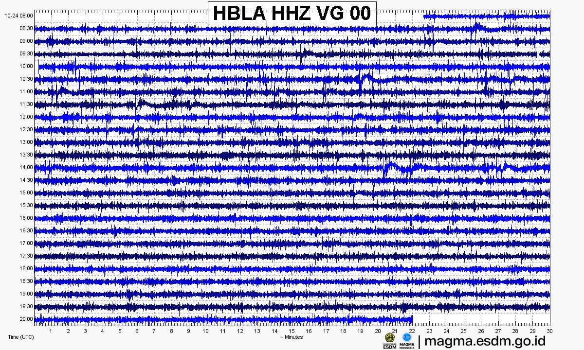
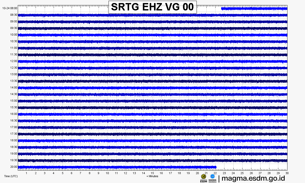
Source: PVMBG – MAGMA Indonesia. Volcanic earthquakes appear as spikes on the trace; continuous shaking may indicate tremor.
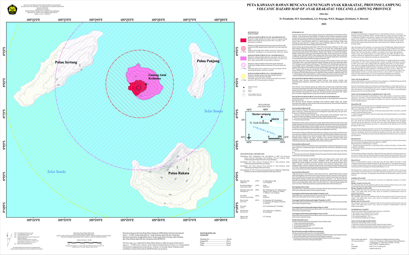
Volcanic hazard map (KRB)
Official Geological Agency map (2007): areas that may be hit by pyroclastic flows, lava flows, ballistic rocks, ashfall, and lahars. KRB III is closest to the source.
14-day seismicity chart
Volcanic earthquakes per day by type.
View data table
| Date | Explosion/eruption | Emission | Shallow volcanic | Deep volcanic | Hybrid/multiphase | Local tectonic | Distant tectonic | More |
|---|---|---|---|---|---|---|---|---|
| 25 Oct | 0 | 0 | 0 | 0 | 0 | 0 | 0 | 0 |
| 24 Oct | 0 | 2 | 0 | 1 | 2 | 0 | 0 | 7 |
| 23 Oct | 0 | 0 | 0 | 0 | 5 | 0 | 0 | 7 |
| 22 Oct | 0 | 1 | 5 | 0 | 38 | 0 | 2 | 13 |
| 21 Oct | 1 | 2 | 16 | 1 | 136 | 1 | 0 | 10 |
| 20 Oct | 28 | 30 | 79 | 13 | 123 | 0 | 0 | 16 |
| 19 Oct | 6 | 20 | 71 | 29 | 133 | 0 | 2 | 26 |
| 18 Oct | 0 | 0 | 0 | 0 | 0 | 0 | 0 | 0 |
| 17 Oct | 0 | 0 | 0 | 0 | 0 | 0 | 0 | 0 |
| 16 Oct | 0 | 0 | 0 | 0 | 0 | 0 | 0 | 0 |
| 15 Oct | 0 | 0 | 0 | 0 | 0 | 0 | 0 | 0 |
| 14 Oct | 0 | 0 | 0 | 0 | 0 | 0 | 0 | 0 |
| 13 Oct | 0 | 0 | 0 | 0 | 0 | 0 | 0 | 0 |
| 12 Oct | 0 | 0 | 0 | 0 | 0 | 0 | 0 | 0 |
Satellite imagery
Previous reports
6-hour report, 2026-10-24, 12:00-18:00 WIB
Visual: The volcano is covered by fog 0-III. Crater smoke not observed.
- 1 Hybrid/multiphase event, amplitude 38 mm, S-P not observed, duration 4 s.
- 1 kali gempa Tremor Menerus dengan amplitudo 5-18 mm, dominan 8 mm.
6-hour report, 2026-10-24, 06:00-12:00 WIB
Visual: The volcano is covered by fog 0-III. Crater smoke not observed.
- 1 kali gempa Tremor Menerus dengan amplitudo 5-18 mm, dominan 8 mm.
24-hour report, 2026-10-24, 00:00-24:00 WIB
Visual: The volcano is covered by fog 0-III. Crater smoke not observed.
- 1 Emission event, amplitude 45 mm, duration 21 s.
- 7 Harmonik events, amplitude 27-47 mm, duration 57-165 s.
- 1 Hybrid/multiphase event, amplitude 38 mm, S-P not observed, duration 4 s.
- 1 Deep volcanic event, amplitude 76 mm, S-P 2 s, duration 13 s.
- 4 kali gempa Tremor Menerus dengan amplitudo 5-45 mm, dominan 10 mm.
6-hour report, 2026-10-24, 00:00-06:00 WIB
Visual: The volcano is covered by fog 0-III. Crater smoke not observed.
- 1 Deep volcanic event, amplitude 76 mm, S-P 2 s, duration 13 s.
- 1 kali gempa Tremor Menerus dengan amplitudo 5-18 mm, dominan 8 mm.
6-hour report, 2026-10-23, 18:00-24:00 WIB
Visual: The volcano is covered by fog 0-III. Crater smoke not observed.
- 1 kali gempa Tremor Menerus dengan amplitudo 5-21 mm, dominan 8 mm.
6-hour report, 2026-10-23, 12:00-18:00 WIB
Visual: The volcano is covered by fog 0-III. Crater smoke not observed.
- 1 kali gempa Tremor Menerus dengan amplitudo 5-16 mm, dominan 8 mm.
6-hour report, 2026-10-23, 06:00-12:00 WIB
Visual: The volcano is covered by fog 0-III. Crater smoke not observed.
- 1 Hybrid/multiphase event, amplitude 72 mm, S-P not observed, duration 9 s.
- 1 kali gempa Tremor Menerus dengan amplitudo 5-48 mm, dominan 10 mm.
Level history
No level changes recorded since monitoring began.