
Mount Karangetang
Sulawesi Utara · 1.784 m a.s.l.
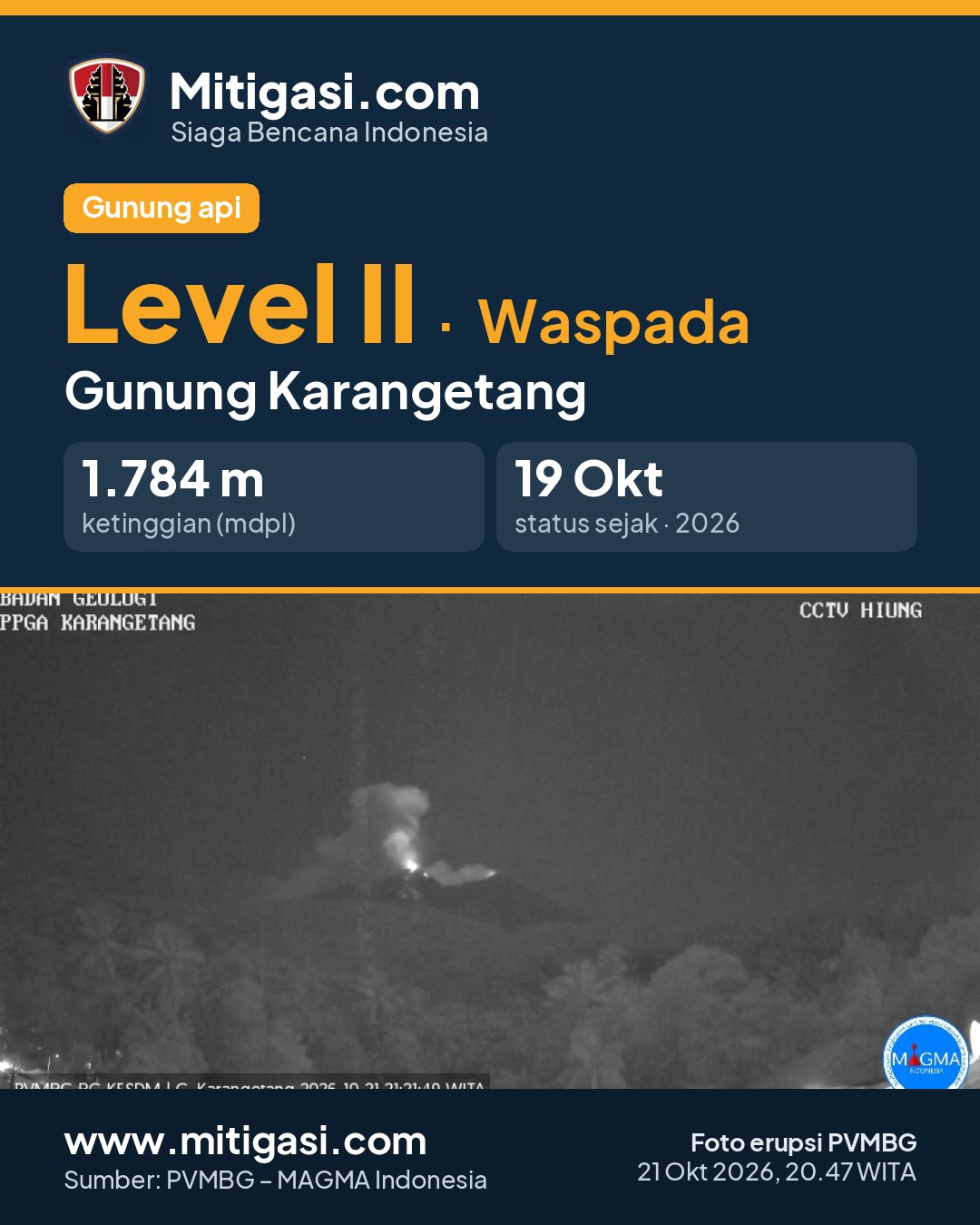
Erupsi terakhir 21 Oct 2026, 20:47 WITA
3 days ago · waktu setempat 21 Okt 2026, 20:47 WITA
Telah terjadi erupsi G. Karangetang,Sulawesi Utara pada hari Wednesday, 21 October 2026, 20:47 WITA dengan tinggi kolom abu teramati ± 800 m di atas puncak (± 2584.0 m di atas permukaan laut). Kolom abu teramati berwarna putih hingga kelabu dengan intensitas tebal ke arah utara dan timur laut. Letusan ini terekam di seismogram dengan amplitudo maksimum 50.0 mm dan durasi sementara +/- 175.0 detik. Letusan masih berlangsung saat laporan ini dibuat.
PVMBG recommendations
(1) Masyarakat dan pengunjung/wisatawan agar tidak mendekati, tidak melakukan pendakian dan tidak beraktivitas di dalam zona prakiraan bahaya yaitu radius 1.5 km dari puncak Kawah Dua (Kawah Utara) dan Kawah Utama (selatan) serta area perluasan sektoral ke arah selatan barat daya sejauh 2.5 km. (2) Mewaspadai guguran lava dan awan panas guguran yang dapat terjadi sewaktu-waktu dari penumpukan material lava sebelumnya karena kondisinya belum stabil dan mudah runtuh, terutama kesektor selatan, tenggara, barat dan barat daya. (3) Masyarakat yang tinggal di sekitar bantaran sungai-sungai yang berhulu dari puncak G. Karangetang agar meningkatkan kesiapsiagaan dari potensi ancaman lahar hujan dan banjir bandang yang dapat mengalir hingga ke pantai.

Recommendations
(2) Mewaspadai guguran lava dan awan panas guguran yang dapat terjadi sewaktu-waktu dari penumpukan material lava sebelumnya karena kondisinya belum stabil dan mudah runtuh, terutama kesektor selatan, tenggara, barat dan barat daya.
(3) Masyarakat yang tinggal di sekitar bantaran sungai-sungai yang berhulu dari puncak G. Karangetang agar meningkatkan kesiapsiagaan dari potensi ancaman lahar hujan dan banjir bandang yang dapat mengalir hingga ke pantai.
Latest report
24-hour report, 2026-10-24, 00:00-24:00 WITA · Muhamad Fadlan Rasyidin Bina
Visual observation
The volcano is clearly visible to covered by fog 0-III. Main crater smoke observed: white with thick intensity, rising about 800 meter dari puncak. Weather clear to overcast, weak wind to moderate towards west and northwest. Air temperature about 20.9-25.1°C. Humidity 40.7-98.8%. Air pressure 690.06-693.06 mmHg.
Terdengar suara gemuruh lemah-kuat Noise angin
Climatology
Weather clear to overcast, weak wind to moderate towards west and northwest. Air temperature about 20.9-25.1°C. Humidity 40.7-98.8%. Air pressure 690.06-693.06 mmHg.
Seismicity
- 40 Harmonik events, amplitude 1.0-50.0 mm, duration 63.0-448.0 s.
- 57 Tremor Non-Harmonik events, amplitude 2.0-50.0 mm, duration 61.0-447.0 s.
- 130 Emission events, amplitude 5.0-50.0 mm, duration 25.0-112.0 s.
- 53 Rockfall events, amplitude 2.0-10.0 mm, duration 19.0-90.0 s.
- 3 Shallow volcanic events, amplitude 2.0-10.0 mm, duration 8.0-13.0 s.
- 3 kali gempa Letusan/Erupsi dengan amplitudo 50.0 mm, dan lama gempa detik.
- 5 Distant tectonic events, amplitude 7.0-50.0 mm, S-P 11.0-22.0 s, duration 34.0-102.0 s.
- 7 Deep volcanic events, amplitude 2.0-40.0 mm, S-P 1.0-2.5 s, duration 6.0-30.0 s.
- 1 Hybrid/multiphase event, amplitude 4.0 mm, S-P not observed, duration 11.0 s.
Observation photo

Latest observation photo.
- Location
- Siau Tagulandang Biaro (Sitaro), Sulawesi Utara
- Nearest city
- Manado
- Elevation
- 1.784 m a.s.l.
- Coordinates
- 2.7800000, 125.4060000
Observation-post CCTV
Snapshots are updated about every 15 minutes. The capture time is shown in the top-left corner.


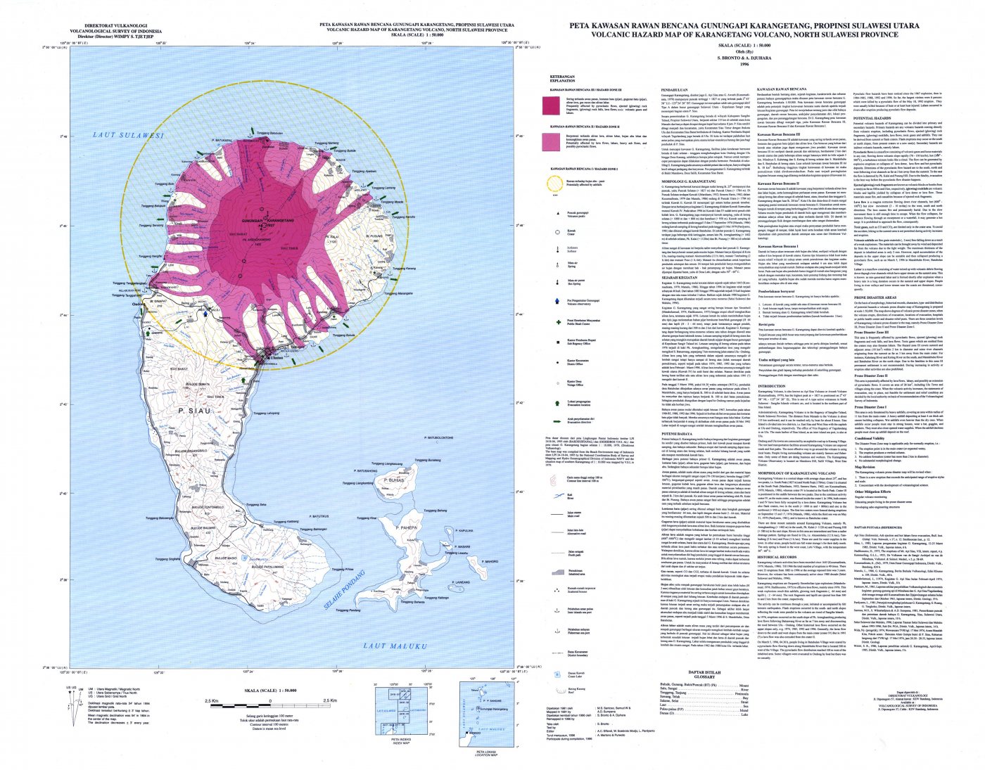
Volcanic hazard map (KRB)
Official Geological Agency map (2011): areas that may be hit by pyroclastic flows, lava flows, ballistic rocks, ashfall, and lahars. KRB III is closest to the source.
14-day seismicity chart
Volcanic earthquakes per day by type.
View data table
| Date | Explosion/eruption | Rockfall | Emission | Shallow volcanic | Deep volcanic | Hybrid/multiphase | Local tectonic | Distant tectonic |
|---|---|---|---|---|---|---|---|---|
| 25 Oct | 0 | 0 | 0 | 0 | 0 | 0 | 0 | 0 |
| 24 Oct | 3 | 53 | 130 | 3 | 7 | 1 | 0 | 5 |
| 23 Oct | 0 | 1 | 103 | 1 | 1 | 1 | 0 | 3 |
| 22 Oct | 0 | 2 | 99 | 1 | 0 | 0 | 0 | 1 |
| 21 Oct | 1 | 47 | 203 | 2 | 9 | 0 | 1 | 9 |
| 20 Oct | 1 | 22 | 92 | 4 | 8 | 0 | 3 | 5 |
| 19 Oct | 0 | 13 | 134 | 0 | 5 | 0 | 0 | 7 |
| 18 Oct | 0 | 17 | 113 | 0 | 1 | 0 | 0 | 6 |
| 17 Oct | 0 | 0 | 0 | 0 | 0 | 0 | 0 | 0 |
| 16 Oct | 0 | 0 | 0 | 0 | 0 | 0 | 0 | 0 |
| 15 Oct | 0 | 0 | 0 | 0 | 0 | 0 | 0 | 0 |
| 14 Oct | 0 | 0 | 0 | 0 | 0 | 0 | 0 | 0 |
| 13 Oct | 0 | 0 | 0 | 0 | 0 | 0 | 0 | 0 |
| 12 Oct | 0 | 0 | 0 | 0 | 0 | 0 | 0 | 0 |
Satellite imagery
Previous reports
24-hour report, 2026-10-23, 00:00-24:00 WITA
Visual: The volcano is clearly visible to covered by fog 0-II. Main crater smoke observed: white with thick intensity, rising about 10-100 meter dari puncak.
- 1 Rockfall event, amplitude 5 mm, duration 33 s.
- 103 Emission events, amplitude 10-50 mm, duration 17-126 s.
- 32 Harmonik events, amplitude 15-50 mm, duration 50-282 s.
- 32 Tremor Non-Harmonik events, amplitude 10-50 mm, duration 60-264 s.
- 1 Hybrid/multiphase event, amplitude 50 mm, S-P not observed, duration 14 s.
- 1 Shallow volcanic event, amplitude 50 mm, duration 6 s.
- 1 Deep volcanic event, amplitude 50 mm, S-P 2.7 s, duration 37 s.
- 3 Distant tectonic events, amplitude 50 mm, S-P 20-22 s, duration 70-100 s.
24-hour report, 2026-10-22, 00:00-24:00 WITA
Visual: The volcano is clearly visible to covered by fog 0-II. Main crater smoke observed: white with thick intensity, rising about 10-500 meter dari puncak.
- 2 Rockfall events, amplitude 5-10 mm, duration 44-59 s.
- 99 Emission events, amplitude 10-50 mm, duration 18-99 s.
- 32 Harmonik events, amplitude 7-50 mm, duration 35-527 s.
- 27 Tremor Non-Harmonik events, amplitude 10-50 mm, duration 66-263 s.
- 1 Shallow volcanic event, amplitude 20 mm, duration 9 s.
- 1 Distant tectonic event, amplitude 40 mm, S-P 20 s, duration 52 s.
24-hour report, 2026-10-21, 00:00-24:00 WITA
Visual: The volcano is clearly visible to covered by fog 0-III. Main crater smoke observed: white with thin, moderate to thick intensity, rising about 5-10 meter dari puncak.
- 1 Explosion/eruption event, amplitude 50 mm, duration 175 s.
- 47 Rockfall events, amplitude 2-20 mm, duration 18-99 s.
- 203 Emission events, amplitude 4-50 mm, duration 22-195 s.
- 37 Harmonik events, amplitude 5-50 mm, duration 31-343 s.
- 100 Tremor Non-Harmonik events, amplitude 3-50 mm, duration 27-371 s.
- 2 Shallow volcanic events, amplitude 10-20 mm, duration 6-10 s.
- 9 Deep volcanic events, amplitude 5-50 mm, S-P 0.86-2.3 s, duration 6-29 s.
- 1 Local tectonic event, amplitude 15 mm, S-P 10 s, duration 48 s.
- 9 Distant tectonic events, amplitude 5-30 mm, S-P 12-35 s, duration 35-93 s.
24-hour report, 2026-10-20, 00:00-24:00 WITA
Visual: The volcano is clearly visible to covered by fog 0-II. Main crater smoke observed: white with thin, moderate to thick intensity, rising about 5-10 meter dari puncak.
- 1 Explosion/eruption event, amplitude 50 mm, duration 39 s.
- 22 Rockfall events, amplitude 3-10 mm, duration 30-106 s.
- 92 Emission events, amplitude 5-50 mm, duration 23-117 s.
- 27 Harmonik events, amplitude 4-50 mm, duration 30-309 s.
- 47 Tremor Non-Harmonik events, amplitude 2-50 mm, duration 28-231 s.
- 4 Shallow volcanic events, amplitude 2-13 mm, duration 6-11 s.
- 8 Deep volcanic events, amplitude 4-50 mm, S-P 0.64-2.46 s, duration 8-23 s.
- 3 Local tectonic events, amplitude 4-50 mm, S-P 6-10 s, duration 30-40 s.
- 5 Distant tectonic events, amplitude 5-50 mm, S-P 16-38 s, duration 55-114 s.
24-hour report, 2026-10-19, 00:00-24:00 WITA
Visual: The volcano is clearly visible to covered by fog 0-II. Main crater smoke observed: white with thin to thick intensity, rising about 5-10 meter dari puncak.
- 13 Rockfall events, amplitude 2-15 mm, duration 12-110 s.
- 134 Emission events, amplitude 3-50 mm, duration 20-152 s.
- 25 Harmonik events, amplitude 2-50 mm, duration 38-327 s.
- 26 Tremor Non-Harmonik events, amplitude 2-40 mm, duration 33-147 s.
- 5 Deep volcanic events, amplitude 7-42 mm, S-P 0.4-1.6 s, duration 5-17 s.
- 7 Distant tectonic events, amplitude 3-50 mm, S-P 17-34 s, duration 43-200 s.
24-hour report, 2026-10-18, 00:00-24:00 WITA
Visual: The volcano is clearly visible. Main crater smoke observed: white with thick intensity, rising about 700 meter dari puncak.
- 17 Rockfall events, amplitude 2-37 mm, duration 13-113 s.
- 113 Emission events, amplitude 3-50 mm, duration 22-135 s.
- 32 Harmonik events, amplitude 2-50 mm, duration 29-328 s.
- 26 Tremor Non-Harmonik events, amplitude 2-16 mm, duration 36-202 s.
- 1 Deep volcanic event, amplitude 50 mm, S-P 0.8 s, duration 16 s.
- 6 Distant tectonic events, amplitude 14-50 mm, S-P 12-40 s, duration 49-90 s.
Level history
No level changes recorded since monitoring began.